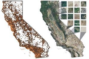
Mapping plant communities — whether to track vegetation change, deforestation or recovery from wildfire — is time consuming and often cannot drill down to small areas. UC Berkeley and Stanford scientists have now used deep learning techniques to correlate citizen science data on plant distribution uploaded to iNaturalist and remote sensing data to build high-resolution maps of California vegetation. They're now trying to do the same in Brazil. This technique could allow daily monitoring of ecosystem changes.
This is an automated archive made by the Lemmit Bot.